Earthquake evacuation planning and risk management with GIS Maps (Ref: BM-124)
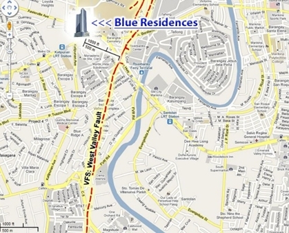
The Marikina Fault System or (The West Valley Fault) in The Philippines, is a fault line which extends from Dingalan and Aurora in the north and runs through the cities of Quezon, Marikina, Pasig, Makati, Paranaque, Taguig, and the provinces of Laguna and Cavite.
This fault is very serious threat to millions of people, as it poses the risk of a large scale earthquake measuring a magnitude 7 or higher. The West Valley Fault usually triggers a large scale earthquake every 400 - 500 years, and with the next big quake currently overdue, the importance of planning for this potential catastrophe can’t be underestimated.

The recent earthquake disaster in Nepal should be a stark reminder that earthquakes can and do happen at any time, and Manila needs to be prepared as best as it can for the very real possibility of a similar event.
A recent article in The Inquirer stated that The Philippine institute of Volcanology and Seismology (Phivolcs) have created updated and detailed maps available to the public that traces the Marikina Fault Line. The maps are a positive step forward, and the general public can use them to check where they live or work in relation to the fault line in order to make necessary plans in the case of evacuation if and when disaster strikes.
As well as the Phivolics online maps mentioned above, there is a much more interactive and detailed GIS mapping software tool available for earthquake risk reduction management and evacuation planning.
With Paperless Trail’s Business Mapper software, earthquake management and evacuation planning is made much simpler and efficient by not only having all the visual information available to you, but also having the ability to interact with maps, which cover the whole of The Philippines. You can do this through selecting and using various layers, buffers, Points of Interest (POIs) and much more in order to visualize, monitor and analyze a huge range of data in relation to planning for a large scale earthquake scenario.
Note: If this article leads to you making an inquiry to us, please use reference RE: BM-124 when you email us with your inquiry.
