Using GIS maps to track & analyze the Philippines elections. (BM-155)
Using GIS maps to track & analyze the recent Philippines elections and results
The recent elections in the Philippines and the accompanying results maps on many news websites and newspapers is the perfect example of how GIS Mapping software can be used to analyze elections and results through using spatial, location based data.
Through using a relatively basic color coded theme tool, you can see who the most popular presidential and vice presidential candidates were by region. You also have the ability to plot and track on the map the amount of votes for each candidate by province/region, as well as the vote share/percentage in a way that is accessible and simple for your average voter to view and understand at a glance.
With the ability to see which candidates were popular with voters in a particular region,
we can gather and analyze useful data and make correlations as to why a specific candidate is popular in a certain areas, and much less popular in others.

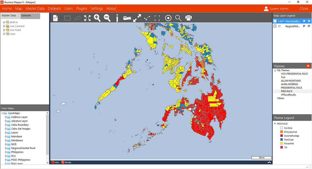
With a quick look at the simple map of the Philippines presidential election results, we can easily deduct that;
- Rodrigo Duterte (Key - Red) was very popular in the capital region of Metro Manila and the instant surrounding areas and provinces. He was also extremely popular and gathered the most votes in the significant areas of the Visayas - Cebu, Bohol and Leyte.
Duterte was also very popular in the majority of the whole region of Mindanao, where he served as the mayor of Davao for 22 years. He is also the only candidate who had significant support from all 3 key demographic regions of the Philippines - Luzon, The Visayas and Mindanao. Duterte won the election by a landslide with nearly 16 million votes, more than 6 million votes more than the candidate who finished in second place, Mar Roxas.
- Mar Roxas (Key - Yellow) had significant support and votes from key areas in The Visayas Region. However, by looking at the map he didn’t have much significant support in any other areas of the Philippines such as Mindanao, Luzon, or the Metro Manila area.
- Grace Poe (Key - Blue), had significant support in Central Luzon and other areas in South Luzon. From the data on the map, it would appear she didn’t have any real significant support in the Visayas or Mindanao regions.
- Jejomar Binay (Key - Orange) had significant support in the far northern region of Luzon, but doesn’t appear to have much support in any other region or areas.
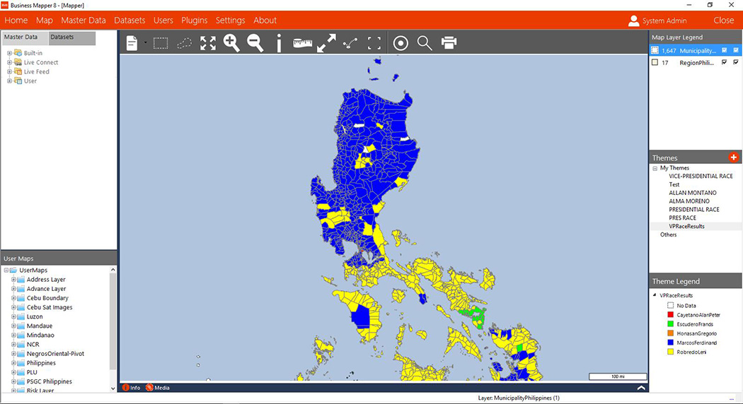
With a quick look at the simple map of the Philippines vice-presidential election results, we can easily deduct that;
- Alan Peter Cayetano (Key Red) had significant parts of support in certain areas of the Mindanao region. This could be due to his association with Rodrigo Duterte - Being his running mate. Cayetano seems to have minimal support in any of the other areas or regions outside of Mindanao.
- Francis Escuedero (Key Green) seems to have minimal support anywhere other than in small pockets of the Albay/Bicol region.
- Gregorio Honasan (Key Orange) appears to have hardly any support from voters at all, with no pockets of orange to be seen anywhere on the map.
- Ferdinand Marcos (Key Blue) appears to have a lot of support from most of the Luzon region including the capital city area of Metro Manila. The map shows that Marcos also seems to have a reasonable amount of support in spaced out pockets of The Visayas, and significant pockets of the Mindanao region.
- Leni Robredo (Key Yellow) has a huge amount of support through nearly the whole of The Visayas Region as well as significant parts of the Mindanao Region. We can also see Robredo has wide support throughout large areas of the Southern Luzon Region.
-Business Mapper Team