Introduction to Digital Maps (BM-140)
Map Projections
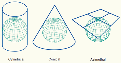
Map projections are attempts to portray the surface of the earth, or a portion of the earth on a flat surface. Some distortions of conformality, distance, direction, scale, and area always result from this process. (Illustration 1).
Different types of Map Projections have different benefits.
Illustration 1:
Map Layers
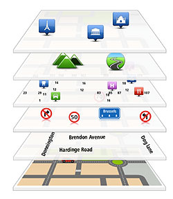
In digital mapping applications, layers are used to organize map content and display. (Illustration 2).
It may appear that maps are flat, but in reality they are composed of various layers and layers types such as;
- Buildings - Points or Polygons
- Rivers - Lines or Polygons
- Streets - Lines
- Points of Interests - Points (maybe displayed with special Icons)
Illustration 2:
WGS 84
WGS 84 is the reference coordinate system used by the Global Positioning System (GPS).
The Global Positioning System (GPS) is a space-based navigation system that provides location and time information in all weather conditions, anywhere on or near the Earth where there is an unobstructed line of sight to four or more GPS satellites.[1] The system provides critical capabilities to military, civil, and commercial users around the world. The United States government created the system, maintains it, and makes it freely accessible to anyone with a GPS receiver.
Why is WGS 84 important to Business Mapper? How about Namria Maps?
Business Mapper uses the WGS84 projection to be compatible with GPS based devices (such as cellphones, navigation systems and tablets) that are commercially available.
These GPS devices make it possible for Business Mapper to do live and real-time mapping. (Live Connect and Field Master) These mobile apps make the cost of field surveys very competitive and covenient.
Namria maps are designed for Philippine reference. However conversions need to be done to make it compatible with GPS devices.
References:
University of Colorado - Article
Wikipedia - Article
Business Mapper Team